The Observation Point Zion trail is easily one of the most underrated and best hikes in Zion National Park, Utah.
Most people go to Angels Landing or The Narrows, which are great hikes, but the scenery at the Observation Point trail is just as amazing and it’s way less crowded! Here, you get a panoramic view of the best sights in Zion National Park from above, including Angels Landing.
Observation Point is currently open as of 2024, although the only way to access it is via the East Mesa Trail to Observation Point. It’s a simple and easy hike with stunning end views, so definitely add it to your Zion bucket list!
This guide for the Observation Point hike will explain where to find the East Mesa trailhead, and everything you need to know before you go!
Quick Facts*
- Distance: 7 miles (11.3 km) round trip
- Elevation Gain: 700 feet (215 m)
- Top Elevation: 6,508 feet (1,983 m)
- Duration: 3 – 4 hours round trip
- Difficulty: Easy / Moderate
*These stats are for the East Mesa Trail to Observation Point

Observation Point Zion National Park
Observation Point Trail: What To Expect
The East Mesa Trail to Observation Point is very tame and straightforward.
I’d rate it as easy for most people, although it could be a bit tougher if you go in the middle of the day when it’s hottest.
Most of the hike is flat, but there’s a bit of descent near the end, which means you’ll have to regain some elevation when you go back.

Typical dirt path on the East Mesa Trail to Observation Point
The trail starts out pretty boring, but that didn’t bother us since we were mainly looking forward to the end view at Observation Point.
We saw very few hikers on the way to the viewpoint, although we passed lots of people afterwards on our way back to the trailhead.
Some pine trees on this trail also give you nice shade along the way, which is a bit unusual for Utah.
Finally, after about an hour of walking, we got our first peek at the giant walls of Zion Canyon below us on the right.
These views are already stunning, but the best is yet to come!

Our first views on the Observation Point hike
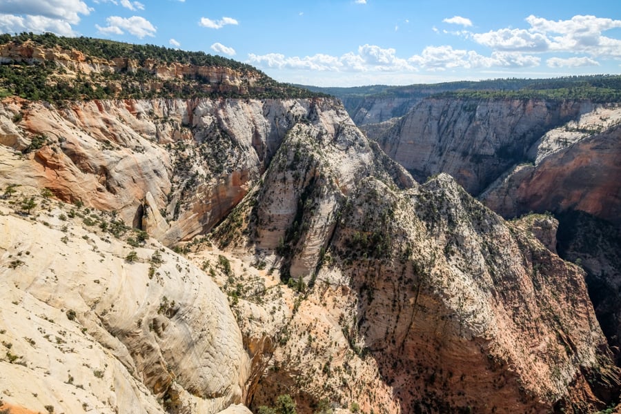
Incredible scenery from the opposite side of the Observation Point Zion trail
Observation Point Zion
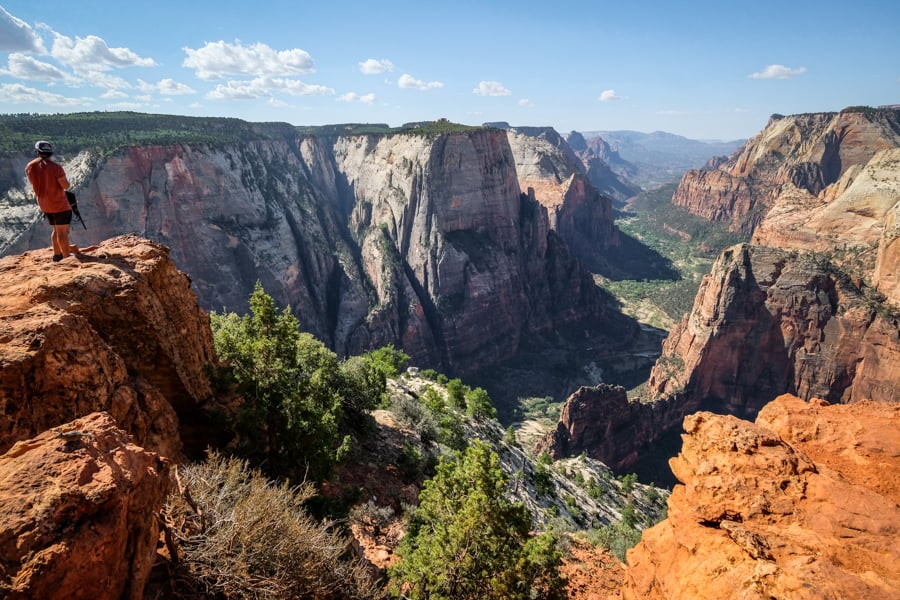
When you first arrive at Observation Point, the panoramic view hits you like a ton of bricks.
Spread out in front of you are many of Zion‘s best sights like the Great White Throne, Cathedral Mountain, and Angels Landing.
We could even see the tiny people hiking to the top of Angels Landing, and the roads and shuttle buses looked like toys in the distance.
The elevation here at Observation Point is 6,508 feet (1,983 m), which is more than 700 feet above Angels Landing, so you really have a bird’s-eye view of Zion National Park.
It’s fantastic scenery, and since this hike is less popular than other places in Zion, you don’t have to worry about sharing it with massive crowds like at Angels Landing and The Narrows.
In fact, if you go early on a weekday you may even have the place to yourself, except for a few chipmunks running around looking for snacks.

Observation Point Trail Zion National Park
Safety At Observation Point
According to the book Deaths And Rescues In Zion National Park by Dave Nally, there have only been a handful of recorded deaths on the Observation Point hike in the last 50+ years:
- 1997 May – Patricia Bottarini, age 36, of Ottawa, Illinois, fell 500 feet to her death while hiking with her husband. Her death was considered suspicious, and her husband was charged, but eventually acquitted by a hung jury.
- 1978 March – David Bourne, age 20, of Lafayette, Idaho, fell 180 feet during the night while camping near Observation Point.
- 1969 September – Norman Chin, age 54, of Fullerton, California, fell 1,200 feet after he apparently slipped while taking photos near a rocky ledge.
I share these stories not to scare you out of doing this hike (no way!), but just to remind you to be careful near any ledges.
The Observation Point trail is very safe overall, and it’s the perfect substitute for Angels Landing if you’re worried about safety. There have been quite a few more Angels Landing deaths over the years compared to this trail.
Families with children can definitely do the Observation Point hike from East Mesa, and most of it is mundane. Just keep an eye on kids when you reach the viewpoint at the end of the hike.

Observation Point Zion
Is Observation Point Open / Closed?
Yes, Observation Point is OPEN as of 2024!
There are two different trailheads for the Observation Point hike: Weeping Rock trailhead or East Mesa Trailhead.
The only way to access it currently is via the East Mesa Trail to Observation Point, and this route is actually much easier than the old route from Weeping Rock!
Weeping Rock used to be the main route to Observation Point, but it was very strenuous since you’d start from the bottom of Zion Canyon and hike all the way to the top.
This is the kind of place where you want to sit forever

Zion Canyon
How To Get To Observation Point Zion
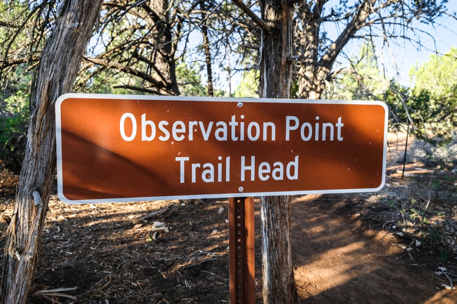
• East Mesa Trailhead (Open)
The East Mesa trailhead is located above Zion Canyon, on the northeast side of the canyon rim.
Here are the GPS coordinates: 37.29809844064629, -112.89980500173893
You can also use the Google map below to navigate you directly to the parking area, which is a 1 hour drive from the town of Springdale, Utah.
• Trailhead Conditions (East Mesa)
The East Mesa trailhead is in need of a facelift. The whole parking lot is dirt (or mud), and there’s very little space to park. In our case it had already filled with cars by 8 AM on a Saturday.
The road to the trailhead is also pretty rough. We didn’t have any trouble passing it with 2-wheel drive and a bit of clearance, but your experience may vary after a rain.
It was fairly dry when we went, so we saw some sedans and SUVs that made it to the trailhead with no problem, but there are a few big ruts so it definitely helps to have high clearance.
Another way to get to the trailhead is with a cheap shuttle transfer from East Zion Adventures. This is a good option if you’re worried about the parking filling up, or if you don’t trust your vehicle to make it to the trailhead.
When you reach the trailhead, there’s an information sign with a map, but no toilets. We also didn’t have any cell service at the trailhead, although there were a few moments where we had spotty service during the hike.
Observation Point Trailhead
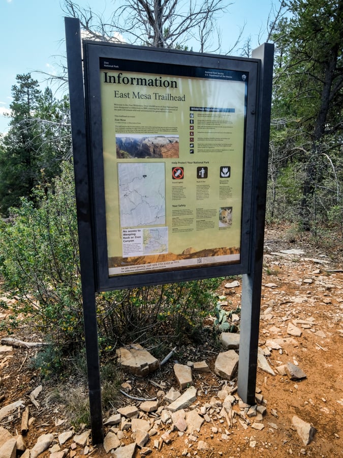
Information sign and map at the East Mesa Trailhead
• Weeping Rock Trailhead (Closed)
The Weeping Rock trailhead was another way to reach Observation Point. It’s located inside of Zion Canyon, and only accessible by shuttle.
This trailhead is currently closed as a result of a big rockfall in 2019 that wiped out part of the trail and switchbacks.
The closure is expected to last for years, so in the meantime it’s not possible to visit Observation Point from this route at all.
Best Time To Visit
Observation Point is spectacular at any time of day, so it doesn’t really matter when you go, although the trail will be hotter and busier at mid-day.
Our photos on this page were taken in the morning, specifically about 10:30 AM, after we waited a little bit for the shadows in the canyon to clear. This was in mid-September.
U.S. National Park Regulations
The East Mesa trail technically starts on BLM land outside of the Zion National Park boundary, but it quickly enters the park, so the usual U.S. national park regulations apply.
The last half of this trail (including Observation Point) is also inside Zion Wilderness boundaries, so the usual wilderness regulations apply, although backcountry permits are not currently required to do this hike.
As always, please remember to keep the trail clean, be considerate of other hikers, and leave no trace. Thanks and happy travels!
Entrance Fee
The East Mesa trailhead is outside of Zion National Park, so you won’t be required to pay any entrance fee to do this hike, although it’s still a good idea to get a park pass.
If you do the hike from Weeping Rock, then you’ll definitely need a national park pass, which is pretty easy to get and you can buy it online or in person.
We normally get the annual pass and visit several U.S. parks in a year, but they also have daily passes. More information and current fees can be found on the Zion National Park website.
Where To Stay At Zion


Best Utah Tours
More Utah Travel Guides
Thanks for looking! I hope you enjoyed this guide for the Observation Point trail in Zion National Park, Utah.
Don’t forget to check out my other Utah hiking guides before you go!
See Also
- Zion Hikes & Trails - Best Hikes In Zion National Park
- Utah Hiking Trails - Best Hikes In Utah
- Angels Landing Zion Hiking Guide
- Slot Canyon Guide - Best Slot Canyons In Utah
- Antelope Canyon Arizona Tours: Which Is Best? (Upper, Lower, X)
2 comments
You said “The elevation here at Observation Point is 6,507 feet (1,983 m), which is more than 700 feet above Angels Landing, so you really have a bird’s-eye view of Zion National Park.”
Not entirely accurate – geodetic marker at the top of Observation Point shows 6508 feet, measured in 1928 by the U.S. Geological Survey. In 2006, i placed my Magellan 300 Explorist GPS next to it, and the Magellan showed 6511 feet. If only those illiterates in 1928 had modern equipment, they might have actually arrived at the “correct” elevation value.!! I still have that photo of course. (Even with WAAS, the altitude on the Explorist was only accurate to +/- 10 feet.) I’ll believe the USGS at 6508.
Thanks, you’re right. I just checked my other photos from our hike, and I see the USGS marker that says 6,508 feet. I’m not sure why so many online sources say 6,507 but USGS is probably more trustworthy. I just updated the article. Cheers