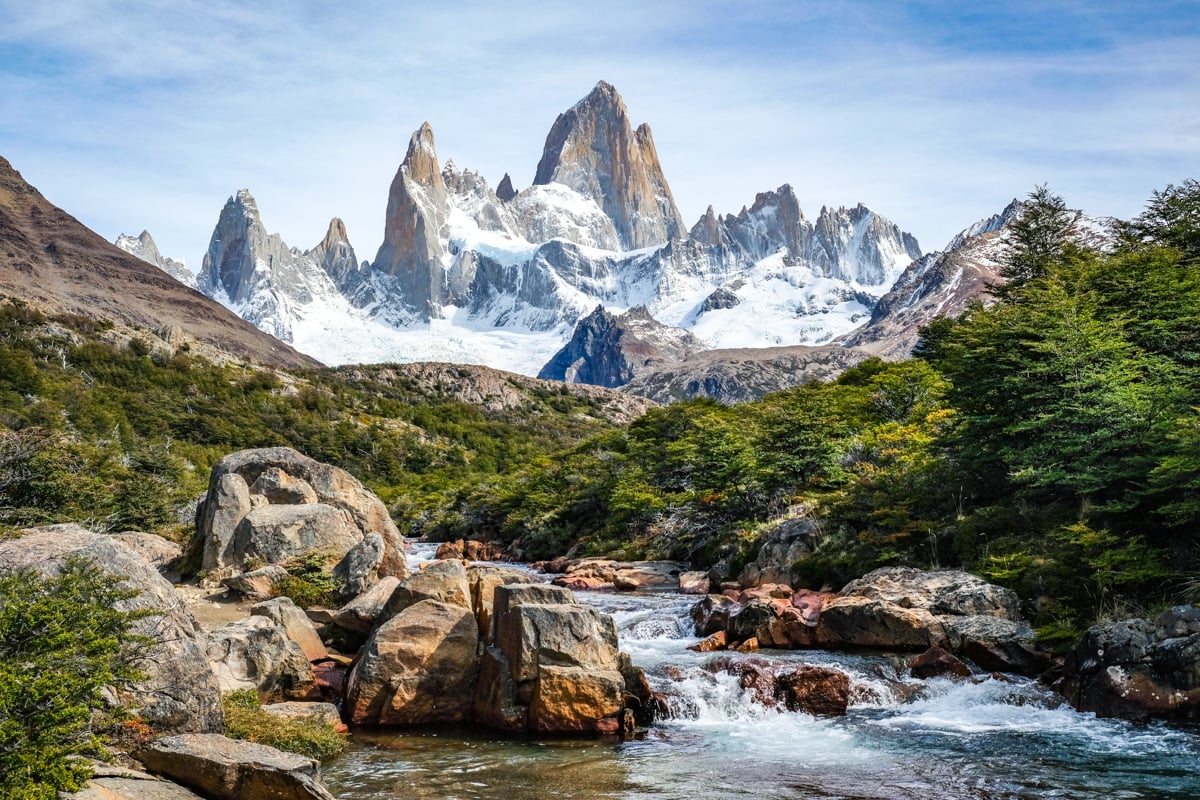
The famous Patagonia region of Argentina has some amazing hiking trails, but the very best would have to be the day hike to Mount Fitz Roy and the Laguna De Los Tres!
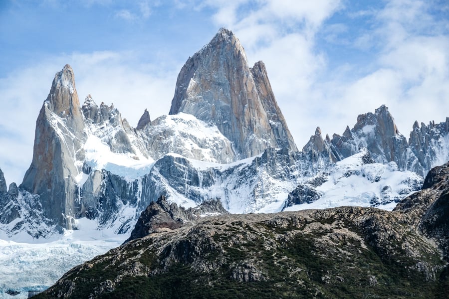
This entire trek is full of great scenery, and at the end you get to see a spectacular blue glacier lake called Laguna De Los Tres, which sits at the foot of Mount Fitz Roy, one of the most impressive and iconic peaks in South America.
The Fitz Roy hike is a challenge, with plenty of distance and elevation gain, but most hikers will still find it very doable. And even if you don’t go all the way to the lakes, you can still get amazing pictures of the mountains from the Fitz Roy Mirador (viewpoint) after only a moderate amount of hiking from the town of El Chalten.
This travel guide will explain how to do the Laguna De Los Tres hike, what to bring, best time to visit, how to get to El Chalten, and everything else you need to know before you go!
Fitz Roy Quick Facts*
- Distance: 22 kilometers (14 miles) return
- Elevation Gain: 1,050 meters (3,445 feet)
- Ending Elevation: 1,175 meters (3,850 feet)
- Duration: 7 – 9 hours return
- Difficulty: Moderate / Hard
*These stats are for the full hike to the lake of Laguna De Los Tres from El Chalten. The Mirador (viewpoint) is shorter and easier.

Final view of the Laguna De Los Tres hike
Where Is Mount Fitz Roy Located?
The Mount Fitz Roy hike is located directly by the small town of El Chalten, in Argentina’s famous Patagonia region.
El Chalten has comfy hotels and restaurants for tourists, but it’s a very small town, so you can easily reach the starting point for this hike from any part of town.
How To Get To El Chalten
There’s no airport in El Chalten, so the closest airport for this hike is the small international one in El Calafate (FTE), which has direct flights from Buenos Aires, Cordoba, Ushuaia, and other places.
The flight from Buenos Aires to El Calafate takes about 3 hours and it’s offered by multiple airlines, with pretty reasonable prices. There are two airports in Buenos Aires (AEP or EZE) and you can use either of them to fly here. You can shop for flights to Argentina on Skyscanner.
Once you arrive in El Calafate, it’s a 3 hour drive to El Chalten. You can get there with a bus, private shuttle, or rental car. The bus service is offered by multiple companies with regular departures.
If you’re short on time, there are also day tours from El Calafate to Laguna De Los Tres (more on that below).

Mount Fitz Roy Patagonia — one of the best hikes in Argentina!
Best Fitz Roy Patagonia Tours
If you’re on a tight schedule and want to visit Patagonia without much advance planning, GetYourGuide has day tours for El Chalten and El Calafate, including some of the best hikes like Laguna De Los Tres!
They have high-rated Fitz Roy day tours that include hotel pickup and drop-off, plus transportation from El Calafate to El Chalten, and optional lunch. A tour like this is not required for the hike, but it can still be a good option if you want to simplify things. They also have day tours to Perito Moreno glacier and other top sights in Patagonia.
We’ve used GetYourGuide for lots of tours and activities around the world, and they’re great. Highly recommended!
Book Now: Laguna De Los Tres From El Calafate
Laguna De Los Tres Hike: What To Expect
The hike to Laguna De Los Tres is an out and back trail that is mostly flat except for a few kilometers of uphill trekking at the start, and then again at the end of the trail.
This is a very popular hike, and it’s usually done as a day hike, but there are also campgrounds along the trail if you want to stay longer and combine it into a loop hike with the nearby Laguna Torre.
The sections below will explain each part of the Fitz Roy hike and what to expect!
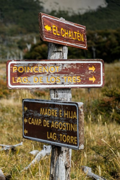
• Starting The Hike From El Chalten
When you first start the Fitz Roy hike, it’s uphill right away. In fact, the first few kilometers have a big chunk of the total elevation gain of the whole trail.
Along the way, you’ll pass some downed trees that make a nice place to sit and rest a minute, and there are kilometer markers to let you know how far you’ve gone on the trail.
For this first part of the hike you’ll mostly be walking through a forest, but there are occasional clearings with great views of El Chalten town and other scenery.

Peeking the valley at Las Vueltas viewpoint
• Las Vueltas River Viewpoint
After hiking about 1 kilometer from El Chalten, you’ll exit the trees and pass a nice little viewpoint of the Las Vueltas river (pictured above).
Here, you’ll get your first great sights of the hike, with the river winding through the valley below, and mountains on all sides.
The Patagonian wind is usually crazy here, so you won’t want to stay very long. But it’s still a great spot to take some quick photos.
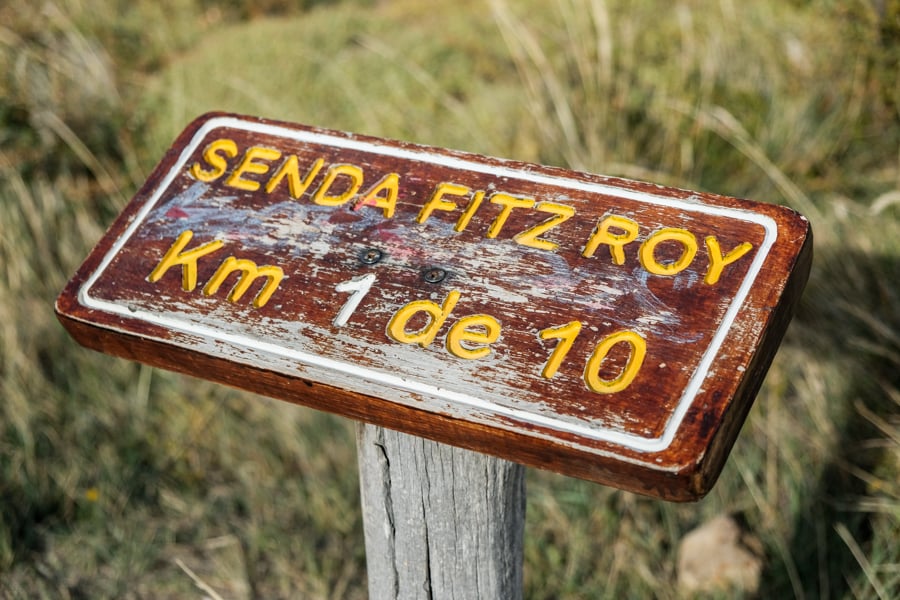
Trail distance marker — 1 of 10 kilometers done!
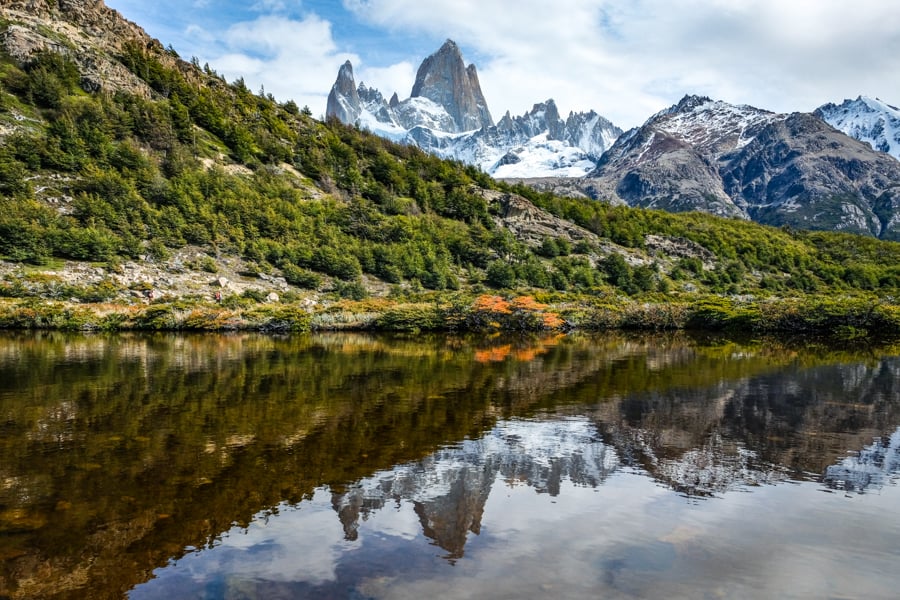
• Laguna Capri
After hiking about 3.3 kilometers, there’s a fork in the path where you can choose to go to either a lake (Laguna Capri) or the Fitz Roy viewpoint.
I would recommend doing the viewpoint on your way up and the lake on your way down. There is also a campground at Laguna Capri if you plan to stay longer.
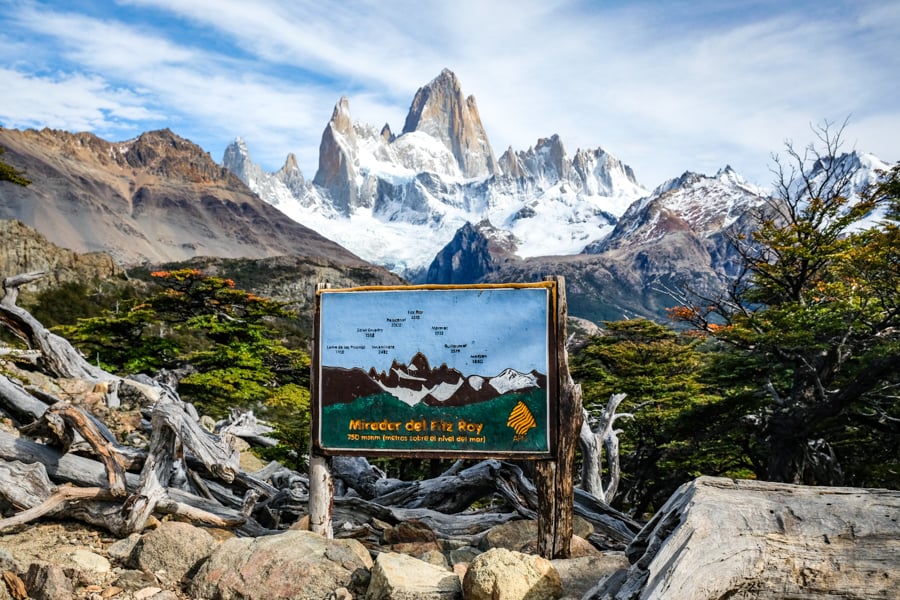
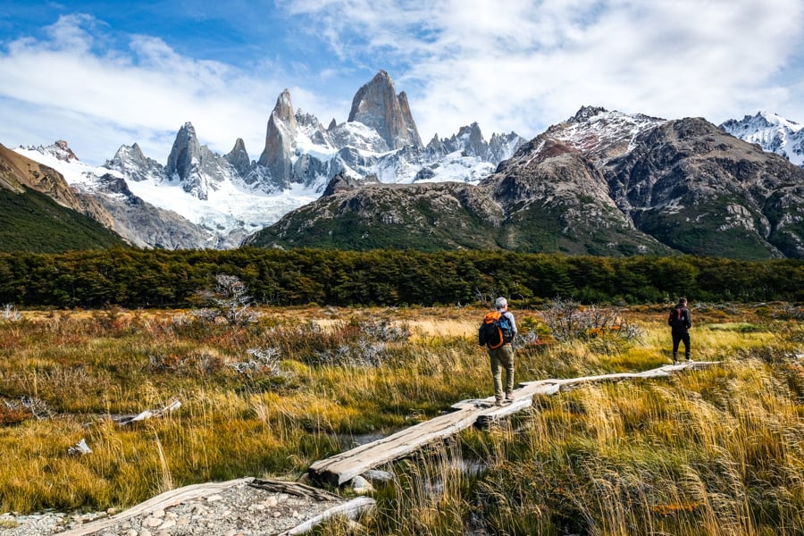
• Mirador Del Fitz Roy Viewpoint
After hiking about 4 kilometers (2.5 miles) from El Chalten, you’ll arrive at the ‘Mirador Del Fitz Roy’ viewpoint, which has some of the most spectacular views of the entire hike.
On a clear day, you have a front row seat to see Mount Fitz Roy and the jagged peaks of Patagonia. Even though the mountains are still far away, they feel so close here! There’s a handy sign at the viewpoint labeling all of the mountain peaks for you.
It really is one of the most stunning sights in the world. The only difference here is that you can’t see the lake of Laguna De Los Tres. That comes later.
This Fitz Roy viewpoint is perfect if you’re wanting a shorter hike with great views!
On a cloudy day, you may not see much at the viewpoint, but I’d encourage you to wait for the clouds to clear, or else come back later and try again.
Because of Patagonia’s always changing weather, I had to re-visit the spot a couple of times before I finally got to see the mountains revealed. All the effort was worth it!
This viewpoint is popular with day hikers, but there’s plenty of space to spread out and take photos. It’s a good spot to break into snacks and drinks, and there’s also a vault toilet in the forest near the clearing.
You can reach the Mirador Del Fitz Roy viewpoint in about 1.5 hours of hiking from El Chalten. All in all, it’s perfect if you want to see great scenery on a shorter and easier hike than going all the way to Laguna De Los Tres!
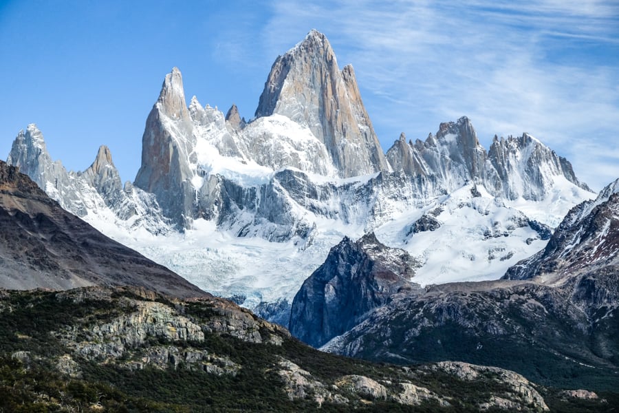
The majestic Mount Fitz Roy Patagonia
• Fitz Roy Secret Waterfall
After hiking about 5.3 kilometers from El Chalten, there’s a short spur trail where you can go see a secret waterfall. The location is marked with an icon on Google Maps and AllTrails.
This is a nice little waterfall with Mount Fitz Roy in the background, and you only have to walk about 150 meters from the main trail to see it! There’s really no danger of getting lost.
Even at the end of summer, the waterfall is still active, and it’s bigger in person than it looks in pictures. It’s a great addition to your trek if you have a bit of extra time and want to take some more photos of Patagonia.
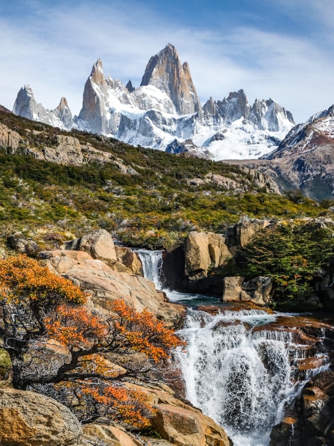
The Fitz Roy secret waterfall
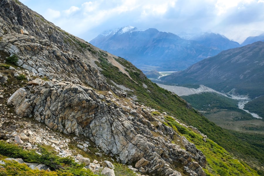
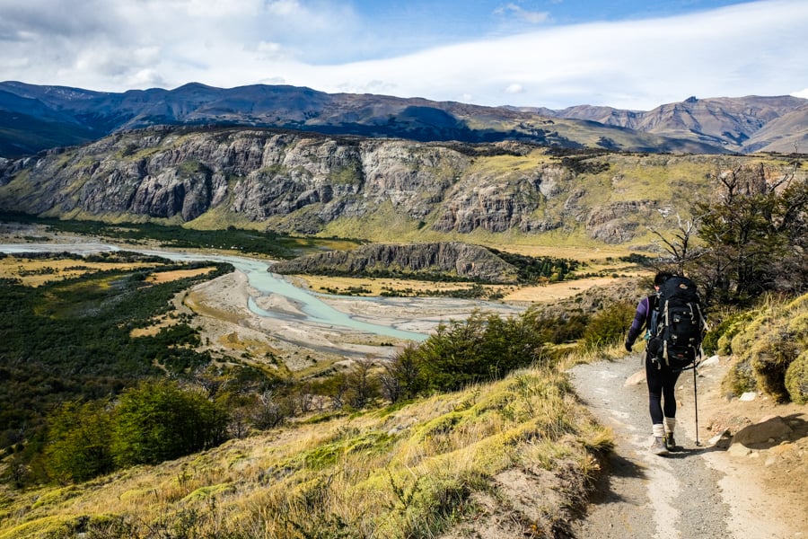
• Fitz Roy Valley To Poincenot
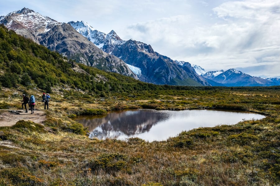
For most of the rest of the Fitz Roy trek, you’ll be walking through a flat valley trail with little to no elevation gain or obstacles.
This is the easiest section of the hike, and it’s one of the most enjoyable parts in my opinion, because the path is almost completely flat, so you can just enjoy the scenery of Patagonia without working up a sweat.
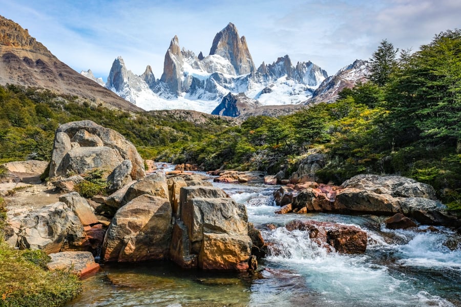
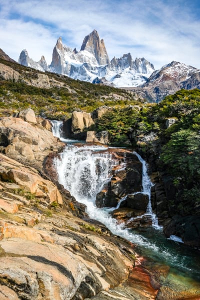
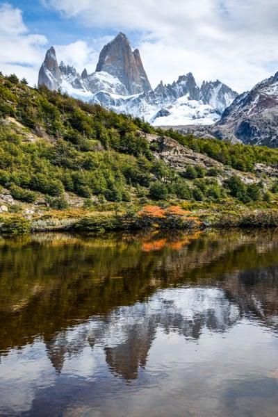
Along the way, you’ll get to see ponds, marshes, meadows, and streams running through the valley, with the ever present Mount Fitz Roy looming in front of you the whole time.
Reflections in a pond
The photo ops here are endless. If you do the hike in autumn, you can see lots of fall leaf colors, but especially red and orange.
You’ll also notice another glacier approaching in the distance. That’s Piedras Blancas, and there’s a spur trail to see it up close if you have time.
Going to the Piedras Blancas glacier viewpoint adds about 2 kilometers in each direction and it’s relatively flat as well.
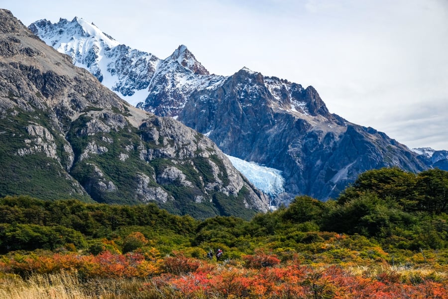
Fall colors with the Piedras Blancas glacier in the distance
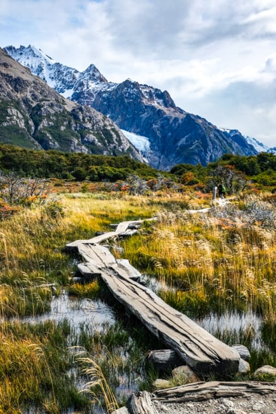
Crossing a marsh
• Climbing To Laguna De Los Tres
Now that you’ve crossed the valley, it’s time for the hardest part of the Fitz Roy hike — the climb to Laguna De Los Tres!
This part involves trekking and scrambling up a steep slope with loose rocks and gravel for the last 2 kilometers (1.2 miles). It’s a big workout, with more than 450 meters of elevation gain.
A sign by the hill warns ‘good physical condition required’ for this section, and I’d say that’s about right. Watch for wet and slippery rocks on the way up.
There are a couple of false summits along the way, and this last part of the hike can take 1.5 hours, even for fit hikers. The wind is often crazy and relentless, so that adds to the challenge.
You can stop for breaks as needed, and there will be plenty of other hikers to give you encouragement, so just keep moving and you’ll finally reach the top!
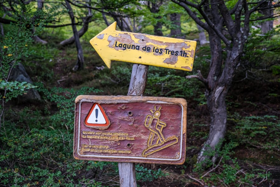
“Trail is very steep. Good physical condition required.”
Beautiful views on the way up to Laguna De Los Tres
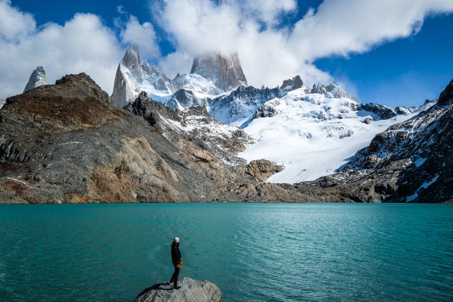
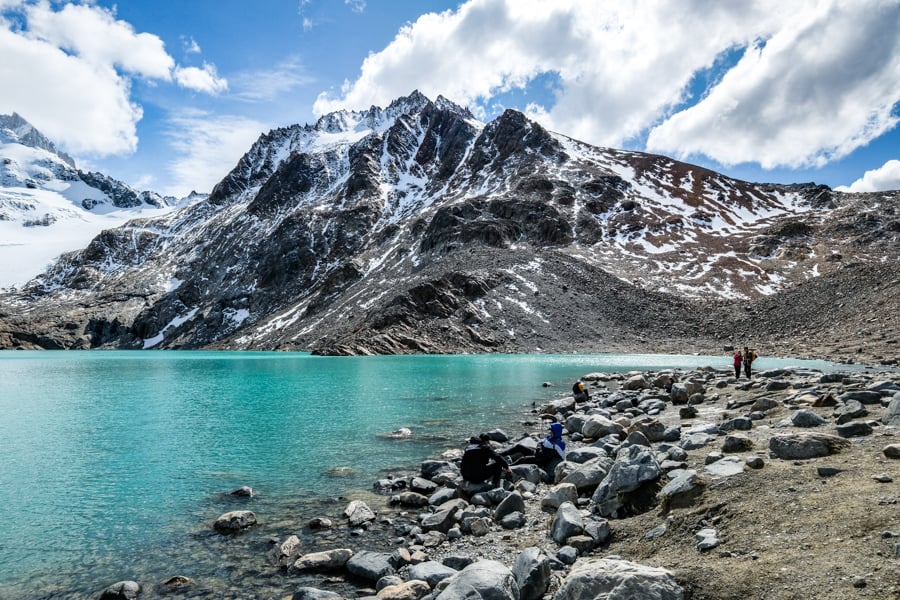
• Laguna De Los Tres: Lake & Viewpoint
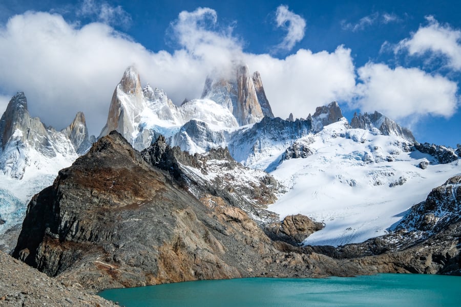
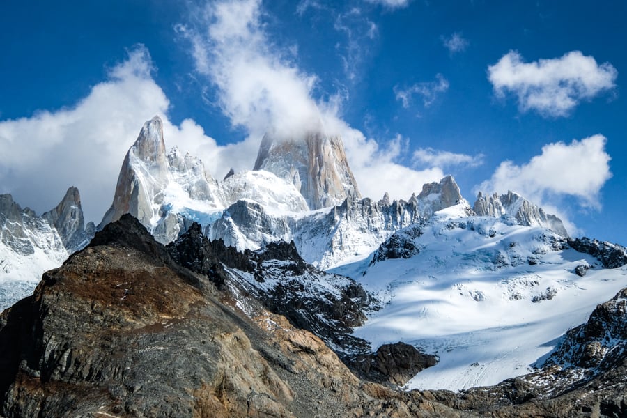
The last reward of this hike is the spectacular blue lake of Laguna De Los Tres. It’s amazing! The name means ‘Lake of the Three’ in Spanish, and it comes from the three peaks surrounding the lake: Fitz Roy, Poincenot, and Saint-Exupery.
You can admire the lake from above, and then hike down the hill to see the lake up close. The melting glacier water gives it a really stunning turquoise color, and there’s even a perfect boulder at the foot of the lake that you can pose on for pictures.
There are actually two lakes here, but in order to see the second one (‘Laguna Sucia’) you have to climb the small hill near the lake. Don’t miss it! From there, you can enjoy panoramic views of both blue lakes, plus a waterfall, and Fitz Roy in between. This is where the hike ends.
In case you’re wondering, only a few people have ever managed to climb the peak of Mount Fitz Roy, and it’s very difficult and dangerous. The pointy peak has an elevation of 3,405 meters (11,171 feet).
Laguna De Los Tres
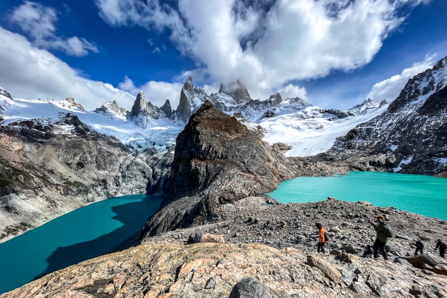
Twin lakes!
The north side of the lake
Fitz Roy Hike Difficulty: How Hard Is It?
Most of the Fitz Roy hike is not very difficult. I would rate it as moderate or even easy.
For example, you can get amazing views by hiking to the Fitz Roy viewpoint, which only takes about 1.5 hours (one way) from El Chalten. To this point, there’s a moderate elevation gain of about 330 meters (1,100 feet). Most of the trail after that is flat and easy until you reach the final climb to Laguna De Los Tres.
If you go all the way to the lake (Laguna De Los Tres), then I’d rate the hike as hard. It’s still not dangerous, and you won’t be climbing with your hands, but it’s long and strenuous and the path gets pretty rough at the end, so it’s a challenge.
From El Chalten, the total one way distance is about 11 kilometers (7 miles) to Laguna De Los Tres, with plenty of elevation gain in the first and last two kilometers of the hike, but the rest of the trail is mostly flat and easy.
So in summary, Fitz Roy is a great day hike for all ages and abilities, and you don’t have to be very fit to see most of it, but the final climb to the lakes is tough, and non-hikers might have an issue with it.
The stunning peaks of Patagonia
Mount Fitz Roy Patagonia — one of the best views in the world!
What To Bring
- Layers: There is a dramatic temperature difference from the trailhead to the final lake, so bring extra layers. I had a t-shirt, sweatshirt, and light down jacket. You’ll want to start the hike without the jacket and wear it later.
- Headwear: For the lake, you’ll want a warm beanie hat that covers your ears. The wind can be crazy and absolutely freezing sometimes.
- Gloves: I wore fingerless gloves so I could work my camera while still staying reasonably warm.
- Footwear: Hiking shoes with good grip are ideal for the Laguna De Los Tres hike. You’ll be walking on slippery rocks and steep inclines or declines at times.
- Poncho: The weather in Patagonia is very unpredictable, so you’ll definitely want to bring a rain jacket just in case. I encountered at least a little bit of rain on every hike I did in Patagonia, even on sunny days!
- Trekking Poles: I didn’t use poles for this hike, but a lot of people say they’re helpful for stability and they make it easier on your knees when you’re coming back down from Laguna De Los Tres.
- Water: Bring plenty of water! The main places you’ll need it are the first and last few kilometers of the hike. There’s drinkable stream water on this hike, so you can carry less water if you make use of that. If you want to be extra careful, you can also bring a LifeStraw. They’re very lightweight and make the water even safer to drink.
- Snacks: I was very glad to have some of my snack bars and beef jerky I had brought from the U.S. You can also bring snacks from El Chalten in a pinch.
- Headlight: This is a long hike, and a light may be required if you start early or late in the day.
- Powerbank: If you plan to use your phone for taking pictures or as a flashlight, then you may want to bring a small power bank. I like Anker, they’re tough and high quality.
- Camera: This hike is full of wonderful photo ops! Any camera and lens will do great. Fitz Roy is so big you won’t need a zoom lens to capture it in photos even from far away, although a wide angle lens can be nice once you get up-close at the last lake.
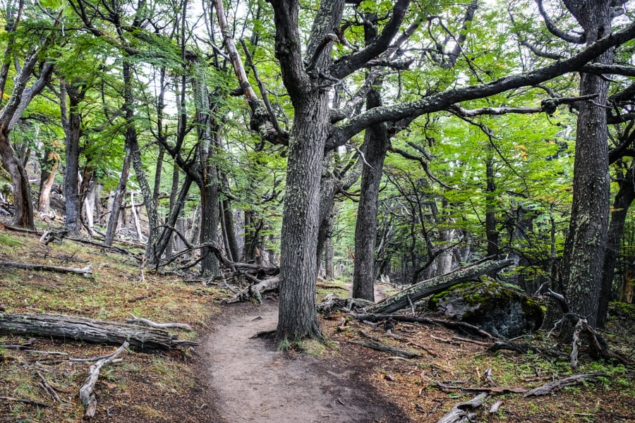
A quiet forest
Best Time To Visit Patagonia
The best time to visit Argentina and do this hike is during the spring, summer, or fall. The summer months run from December to February, and these months have some of the longest days and best hiking weather, but they’re also more popular and expensive.
The shoulder months of March, April, and November can also be great, although the temperatures may be a bit cooler. All of the pictures in this travel guide were taken in mid-March, which seemed just about perfect to me. There was even some nice fall foliage at that time, although it wasn’t quite at its peak yet.
The best time of day to start this hike is in the morning (anywhere from 6 to 9 AM) if you want to beat the crowds or see the sunrise colors reflecting on the mountain peaks. Later in the day there will be a lot more hikers, so you might have traffic jams on narrow paths like the final climb up to Laguna De Los Tres.
The weather in Patagonia is completely unpredictable, so don’t worry too much about forecasts. I saw ‘sunny’ days where the mountain peaks were completely covered by clouds, and ‘rainy’ days where the mountains were completely clear for most of the day. My Fitz Roy pictures on this page were taken on a ‘rainy’ day according to multiple weather forecasts!
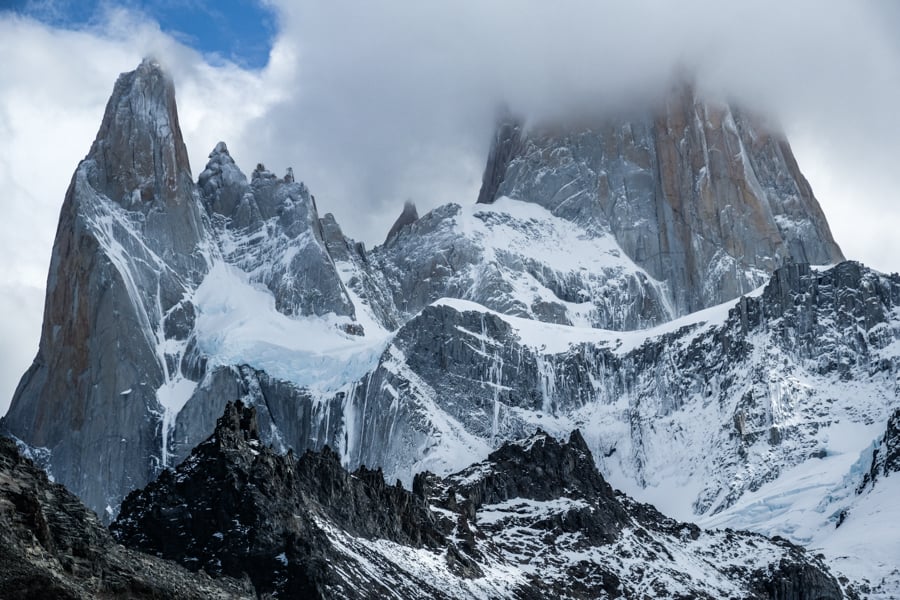
Fitz Roy looks epic even in the clouds
Other Tips For The Fitz Roy Hike
- Wildlife: You can see condors, foxes, hares, guanacos, and Andean deer. There are also pumas in Patagonia, including some in the Fitz Roy area, but these big cats are more rare to see. Remember to store your food safely and out of reach at the campgrounds, or you may get visited by a puma.
- Bugs: I never saw any bugs on the Fitz Roy trek, but others have mentioned biting flies in the summer, so you may want to bring bug spray just in case. Thankfully there aren’t mosquitoes in Patagonia.
- Water: There is potable fresh glacier water at many points in the hike. The best and safest drinking water to take is from the river Rio Blanco, which you’ll pass right after the Poincenot campground. You can also use a LifeStraw for drinking if you want to be extra careful.
- Toilets: There’s no toilet at the trailhead. However, there’s a vault toilet at the Mirador (Fitz Roy viewpoint), and another one at each of the campgrounds on the trail. Make sure you take care of business before the final climb to Laguna De Los Tres, because there are lots of people at the lake and it’s a wide open space with nowhere to pee.
- Cell Service: There’s no cell service/phone reception after you leave El Chalten town, except for a little bit near the Vueltas river viewpoint. Aside from that, you won’t have any reception on the trail or at the lake (Laguna De Los Tres).
- Drones: Argentina doesn’t allow drones on this hike since it’s part of the national park.
- Entrance Fee: Free! Even though this hike is part of the Los Glaciares National Park, they don’t charge any entrance fee here, unlike the Perito Moreno glacier in El Calafate. You don’t need any guide or permit either.
- Campgrounds: There are free campgrounds at Laguna Capri (near the Fitz Roy viewpoint) and also at Poincenot later in the hike.
Another pond on the way to Laguna De Los Tres
Other Tips For El Chalten Town
- Hotels: There are a bunch of comfortable hotels and hostels in El Chalten town if you plan to stay longer. Check out Kaiken Hostel for a budget option, Fitz Roy Hosteria for midrange, and Destino Sur Hotel for high end.
- Restaurants: The town has plenty of restaurants and great food. A nice breakfast option is La Esquina, and for dinner check out La Cerveceria or La Vineria Grill & Pasta.
- Credit Cards: Many places in town accept credit cards now, but some are still cash only. Bring enough cash just in case. The ATMs in town are not very reliable.
- Money Changers: You can find money changers (‘cambio’) in El Chalten, although they sometimes run out of cash. It’s best to change your cash in El Calafate or Buenos Aires if you can.
- WiFi: The hotels in El Chalten have slow WiFi or none at all, but the situation is improving. Some of the cafes have fast WiFi if you look around. The best WiFi I found was at La Esquina.
- Cell Service: With T-Mobile roaming, I had cell service/phone reception from Claro in El Chalten town, but it wasn’t the greatest. The Argentine government is working on improving this soon.
- Supplies: There are plenty of grocery and convenience stores in El Chalten, as well as shops where you can buy or rent tents, sleeping bags, backpacks, jackets, and all kinds of other equipment for camping and hiking. I’m sure it’s more pricey than bringing your own gear, though, so do that if you can.
- Safety: Argentina is a pretty safe country overall, and the Patagonia region is especially safe. Generally you don’t have to worry about crime here. I’ve started the Fitz Roy hike alone in the dark with no worries. By morning, there are always plenty of people on the trail. Everyone brings a camera to El Chalten too, so you won’t stand out for that. Just practice normal precautions. Don’t leave cash in your room, or valuables in your car.
The unforgettable Laguna De Los Tres
Fitz Roy Trailhead Location: How To Get There
The main Fitz Roy trailhead is located at the end of Avenida San Martin (the main road in El Chalten), at the north end of town.
The entrance to the trail is basically right next to town, and El Chalten is small enough you can easily walk to the starting point of the hike from anywhere in town in about 15 minutes or less.
You can use this GPS location to route you directly to the trailhead entrance. It’s marked in Spanish on Google Maps as ‘Sendero al Fitz Roy.’
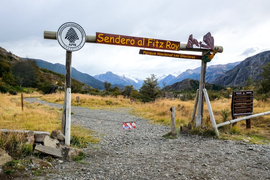
Fitz Roy trailhead entrance and starting point
El Chalten Trailhead Conditions
The Fitz Roy trailhead has a big gravel parking lot with enough space for plenty of cars. I never saw it fill up, even though this is a very popular hike that attracts day trippers and backpackers from El Calafate and even Torres Del Paine in Chile.
When you arrive at the trailhead there’s a big trash disposal bin, a faucet with potable drinking water, and an information sign telling about the hike details, trail map, elevation profile, and Argentine national park rules.
Strangely there’s no toilet at the Fitz Roy trailhead, so you’ll want to take care of business before you get there, otherwise you can find vault toilets later in the hike.
As always, please remember to keep the trail clean, be considerate of other hikers, and leave no trace. Thanks and happy travels!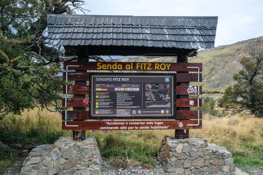
Information and map at the trailhead for Laguna De Los Tres
Alternative Trailhead: El Pilar
For an alternative hike to Fitz Roy, you can start from El Pilar, which is north of El Chalten town.
The main advantage of this route is that it’s slightly easier and has less elevation gain, and you’ll be hiking directly past the Piedras Blancas glacier, so you get nice views of another glacier without any extra hiking. Plus, it’s a point-to-point hike like this, so there’s more variety in the scenery compared to doing it as an out-and-back.
The main disadvantage of hiking from El Pilar is that it starts outside of town, so you have to do a bit of extra traveling — the drive is 40 minutes, to be exact, and Chalten Travel has a bus that goes there. You also won’t get to see Mount Fitz Roy quite as often on this route, so if that’s your main goal then you might want to go from the normal trailhead at El Chalten.
However, for veteran hikers who have already done the trek to Laguna De Los Tres from the normal trailhead, starting from El Pilar instead can be a great way to shake things up a bit!
Walking back to El Chalten town
Is The Fitz Roy Hike Worth It?
Yes, this hike is absolutely worth the effort!
Fitz Roy is one of the most impressive mountains I’ve ever seen. The lake is wonderful too. Even if you don’t have enough energy to go all the way to Laguna De Los Tres, you can still enjoy some amazing sights at the earlier viewpoints.
It’s a bucket list trek for sure, and easily one of the best day hikes anywhere in South America. On a clear day, I’d even say it’s one of the very best hikes in the world.
Mount Fitz Roy coming out of the clouds — Patagonia at its best!
More Patagonia Travel Tips
Thanks for looking! I hope you enjoyed this guide for Mount Fitz Roy and the Laguna De Los Tres hike in Patagonia, Argentina.
Don’t forget to check out my travel blog post about the Perito Moreno glacier, which is another stunning sight in Patagonia near the town of El Calafate!
Happy travels!